Back to Top

Bacau tourism

Blog Archives

VB Baltata-Coliba Vanatorilor Trail

Categories: Hiking, Trail running

Distance: 9.5Km
Elevation+: 400m
Elevation-: m
Difficulty: 3
Route type: Circuit
Marked/Virtual: virtual

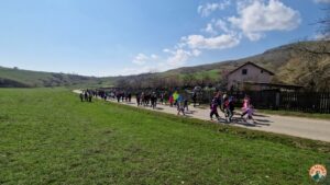
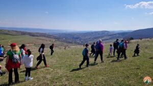
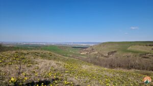
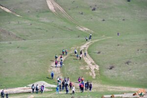
A picturesque route that takes you through scenic but also historical places.
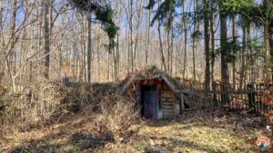
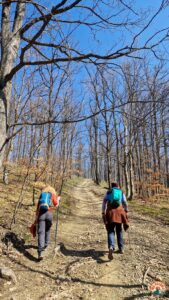
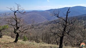
The trail starts from the lower part of Bălțata, passes by the Orthodox Church of the Nativity of the Virgin Mary (founded in 1830), passes through the pine forest and reaches the Hunters’ Hut, a good place to stop and picnic. From here we return to the Runc peak and descend to the Albeni saddle, at the end of Albeni Street in the Seaca Valley. It is said that this was a royal prison during the reign of Prince Stephen the Great, hence the name Albeni, from the name of the albini.
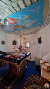
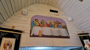
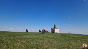
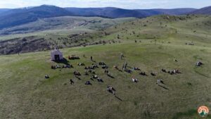
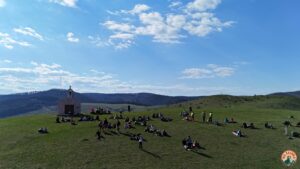
From the Albeni saddle you go up to the Chapel of the Ascension of Jesus to Heaven (or Albeni chapel).

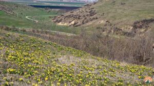
From Albeni chapel we descend to the starting point. In spring, here, in the first part of April, we will enjoy the presence of the blossoming rurescue.

The trail is an easy-medium route also good for walking with children.

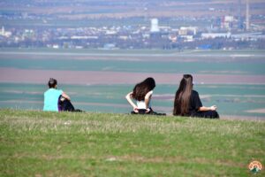
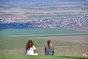
Let the images do the talking.


Download GPX

Via Bacovia Trail – Short race

Categories: Bike MTB, Hiking, Thematic routes, Trail running

Distance: 7.3Km
Elevation+: 330m
Elevation-: m
Difficulty: 2
Route type: Circuit
Marked/Virtual: marked

A shorter route for a possible Via Bacovia Trail race.

The start/finish point is also in the square of the “Ascension of the Holy Cross” church in Luizi Călugăra.

Objectives on the route:


Download GPX   Open map

Route Delta Bacau

Categories: Bike MTB, Cross bike, Hiking, Thematic routes, Trail running

Distance: 11.5Km
Elevation+: m
Elevation-: m
Difficulty: 3
Route type: Itinerary
Marked/Virtual:

Motto: Bacău– The city with the delta

Thematic trail

Route Administrator: CRE Bacau

This route is virtual. Via Bacovia is taking the necessary steps for the implementation and official endorsement of this route.
Current version: 1.1 
Last update: 23.10.2024 
List of changes: see at the end of the document

An easy route around Lake Bacău II – Bacău Delta.
The proposed route is circular and has 3 start-finish points.

Lake Bacău II or Bacău Delta is a protected area, it is part of the protected natural area “Buhuși-Bacău-Berești Reservoirs”. The area is entirely within the administrative area of the municipality of Bacău.

The access to the lake is possible from several areas: from Stefan cel Mare street, from the Serbbaesti bridge area, from the Moldavian way, e.t.c.

The Bacovian Delta Trail runs around Lake Bacau II, being a circular route that also involves crossing the Bistrița riverbed, in the area near the Gherăiești Park. It is approximately 11.5 kilometres long.

The route runs along the lake embankment from Stefan cel Mare street, crosses …

Continue Reading

Cucuieți Ridge Trail

Categories: Hiking, Thematic routes, Trail running

Distance: 7.5Km
Elevation+: m
Elevation-: m
Difficulty: 2
Route type: Circuit
Marked/Virtual:

1. Introduction

The Culmea Cucuieți trail is part of the Via Bacovia network and proposes a balanced incursion between recreational hiking and exploration of a particularly valuable protected natural area – the Culmea Cucuieți natural area, in Bacău County.
With a total length (round-trip) of about 7 km, a difference in level of about 300 m and a medium degree of difficulty, the route is suitable for regular hikers looking for an authentic experience in nature, with wide views of the hills in the eastern part of the county.

The route follows forest and open roads and is relatively easy to follow. In spring, summer and late summer, some stretches of the trail may be overgrown.

2. General description

The route is a round-trip, 3.5km per segment, totalling 7km (approximately) starting from Strada pe Vale, Buhoci and climbs to the ridge on Dealu Mare, above the protected area. The undulating topography and the succession of glades, deciduous forests and open sectors offer a particular landscape variety.
Along the way, the trail alternates between compact beech and oak-oak …

Continue Reading

Route “Emil Braescu” Magura

Categories: Bike MTB, Hiking, Trail running

Distance: 11Km
Elevation+: m
Elevation-: m
Difficulty: 3
Route type: Itinerary
Marked/Virtual:

A beautiful trail, medium difficulty for hikers, difficult for MTB.

The route starts and ends at the last public transport station in Magura. Public transport services from Măgura to Bacău are hourly on the hour during the working day and from Bacău to Măgura hourly on the hour and a half.

The route follows the valley of the Negel stream and after a few kilometres turns right, climbing up the forest road and crossing some beautiful glades. At the highest point on this route we will cross the forest road that descends from the Pietricica peak towards Sohodol, here we turn right on this road.


Download GPX

Via Bacovia Trail Cros

Categories: Bike MTB, Hiking, Trail running

Distance: 12Km
Elevation+: m
Elevation-: m
Difficulty: 3
Route type: Circuit
Marked/Virtual:

The routes of the Via Bacovia Trail competition stretch over the beautiful western hills of Bacau. The trails follow forest and meadow roads and paths, taking you through beautiful, gentle forests and over hills that offer beautiful views of Bacău, villages and the valley.

This is the route of the 2022 edition, organised by the Oleacă Bicyclists Association and the County Athletics Association, with funding from the Bacău County Council.

Link competition page: vbtrail.ro

Nature of the land

The terrain surface is typically hilly, with most of the route being clay. In places the running surface will be covered in leaves under which twigs and stones may be hidden. On some small stretches we will have rock/stone and a very small part, after the start and before the finish, tarmac. In wet weather we will have to deal with soft, slippery surfaces, which is why running shoes with moulded ‘hard ground’ soles are recommended – we recommend these, soft ground soles can only be used if the ground is dry.

Map legend:

The route has approximately 12km and 500m …

Continue Reading

Route 6 Chapels

Categories: Hiking, Pilgrimage, Trail running

Distance: 25Km
Elevation+: m
Elevation-: m
Difficulty: 4
Route type:
Marked/Virtual:

Current version: 1.0 
Last update: 13.06.2023 
List of changes: see at the end of the document

A particularly beautiful route that takes you to all 6 chapels that are located in the hills west of Bacău. In addition, the Grotto of St Mary the Virgin (Luizi Călugăra) and the Hunters’ Hut are also on this route.

The route starts at the Osebiți Cemetery and ends at the Chapel of St Emperors Constantine and Helen, a jewel of a chapel with historical monument value (built in 1888).

The return to the starting point can be done either by car from Buchila or Valea Seacă or on foot, following the ridges of the hills. Via Bacovia maps can be used as a guide.

Below are some images, taken in May 2023, of the route.


List of changes
1. 13.06.2023: create route

Download GPX

Route south chapels

Categories: Hiking, Pilgrimage, Trail running

Distance: 16Km
Elevation+: m
Elevation-: m
Difficulty: 3
Route type:
Marked/Virtual:

Current version: 1.0 
Last update: 16.06.2023 
List of changes: see at the end of the document

The route is of medium difficulty and starts in the dry valley at the base of Albeni hill – the main route being the one marked with the thick orange line. There is also the option to start from Bălțata (the yellow-thin route) which will add about 3km to the length of the route and a difference in level of about 210m, passing through a beautiful pine forest.

The route will take you to the chapels of Capela Sfinților Împărați Constantin și Elena , Ciciola Chapel, the Ascension of Jesus to Heaven. Below are some photos from the start in April 2023.


List of changes
1. 16.06.2023: create route

Download GPX

Măgura-Răchitișu-Sohodol route

Categories: Bike MTB, Hiking, Trail running

Distance: 21Km
Elevation+: m
Elevation-: m
Difficulty: 3
Route type:
Marked/Virtual:

Current version: 1.0 
Last update: 20.06.2023 
List of changes: see at the end of the document

A less travelled route, but with its own beauty. A route of medium to high difficulty for running and hiking and hard for MTB.

The route starts and ends in front of the town hall of Măgura.We leave from the town hall towards Dealu Mare, with a short stop at the Gherț chapel. From here we head towards Măgura Verde, we leave the main road and after crossing the DN11 we descend into the valley of the Negel stream, which we walk along for a while, then we climb up to the Pietricica peak, where we have a beautiful view of the valleys and the Berzunți mountains, and on clear days we can see the Ceahlău Massif in the distance. After a fairly short descent we reach Răchitișu where we stop at the beautiful church of St Dumitru, a church perched on a hill at the foot of the forest. From here we head downhill, following the forest road towards Pădureni, and before Pădureni we …

Continue Reading

Route Trebeș Cross

Categories: Bike MTB, Cross bike, Hiking, Trail running

Distance: 11.5Km
Elevation+: m
Elevation-: m
Difficulty: 2
Route type:
Marked/Virtual:

Current version: 1.0 
Last update: 14.07.2023 
List of changes: see at the end of the document

An easy trail that runs almost entirely on forest roads and in the woods. It is one of the most popular running routes around Bacău, excellent to run on hot summer days as almost all of the route is through woodland, making it shady.

The starting point on the route is at the barrier on Cantonului Street in Trebeș village.


List of changes 
1. 14.07.2023: create route

Download GPX